HOME
The SplittingDataBase is an open-access database. If you use the data or maps in publications, please to cite the SplittingDataBase using the following reference:

Wüstefeld, A.; Bokelmann, G. H. R.; Barruol, G.; Montagner, J.-P. (2009) "Identifying global seismic anisotropy patterns by correlating shear-wave splitting and urface waves data" , Phys. Earth Planet. Int, 176 (3-4), 198-212, doi:10.1016/j.pepi.2009.05.006   (database available online at http://splitting.gm.univ-montp2.fr/DB)


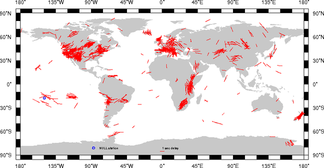
Download database file in txt format: with 68611 splitting measurements
 splittingDB.txt (6449.2 kB) last modified: 22 Dec 2023 01:02

Download reference file in txt format: with 363 references
 splittingDB_ref.txt (110.4 kB) last modified: 22 Dec 2023 01:02

Download complete database in GoogleEarth format:
 splitdatabase.kmz (1805.1 kB) last modified: 22 Dec 2023 01:02

Download also our little script examples, showing how to read the text files into your application:
Matlab: readsplittingDB.m
GMT: map.gmt.sh


Click on map to download image in PostScript format
(This map is not updated automatically and does not always represent the current contents of data base)


How to change the color of the splitting markers?
  1. Load the splitting-database in GoogleEarth
  2. right-click on the splitting-database placemark in the "GE-Placemark-Browser"
  3. Select Copy
  4. Paste the contents of the clipboard into any text editor. The database is converted into its .kml text equivalent.
    This may take a while, since the resulting file has a few thousand lines
  5. At the top of the file search for a section looking like

    <Style id="FastAxisMarker">
      <IconStyle>
        <color> #ffeeeeee </color>


  6. Change the HEX-code of the color Tag. The order is:[transparency blue green red]
    The range of values for any one color is 0 to 255 (00 to ff). For alpha, 00 is fully transparent and ff is fully opaque.

    For example:
      blue markers: #ffff0000
      red markers: #ff0000ff
      yellow markers: #ff00ffff
      dark pink markers: #ffff55ff
      orange markers: #ff0099ff
      grey markers: #ff999999

  7. Save the text file with extension .kml
  8. Open that file in GoogleEarth
  9. Right-click on your newly created ow database in the placemark-browser
  10. Select Save as...
  11. Save it as a .kmz-file for it is smaller and the icon in inlcuded in the file